Tuesday, October 6, 2020

A bit of Roadside Americana


We left Cheyenne in the early morning hours and drove to Mormon Island State Recreation Area. Located just off I-80 it makes a great overnight camp location. This a well maintained facility providing electricity and a dump station. The wash houses are clean and have showers. Named for the winter stopover used by Mormon emigrants heading westward.

Our meals for this trip are made from from leftovers we saved over the summer and froze. Things like soups, casseroles, chili etc. same with breakfast mostly breakfast sandwiches. Lunch is made up of sandwiches and fruit and veggies.

On the morning of October 5 we traveled south from Mormon Island on Rt 281 to Hastings, Nebraska. It is a very little known fact that Kool-Aid was invented in Hastings, NE.


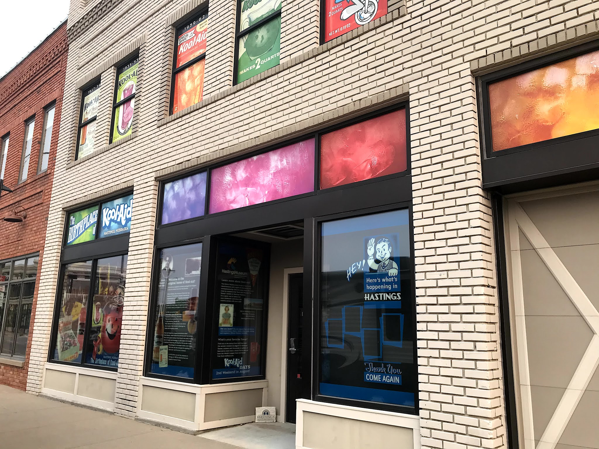
In 1927, Edwin Perkins invented and began to manufacture Kool-Aid at Perkins Products Company in Hastings. The Original Kool-Aid Factory, the original home of Perkins Products Company, at 516 West 1st Street.  He had a dream of being a self-employed businesses success was backed by hard work and some ingenious marketing. While he developed many products, Kool-Aid was certainly the most famous and has gone on to impact popular culture through the decades.

The outside of the building is a colorful tribute to Perkins products, but mostly Kool-Aid.

I found Hastings to be a classic midwest town with brick streets and a vibrant down town shopping area. One could spend a good bit of time walking the main street area window-shopping and visiting one of the many coffee shops.

As we continued South on 281 into Kansas to a spot one mile North of Lebanon, Kansas. Here one find a nice little park and the Geographic Center of the 48 Contiguous States.


It was in 1898 a government geodetic survey determined that the geographical center of the 48 continental states was located at 39 degrees latitude and 98 degrees longitude.

Here is a stone monument which was erected on the exact spot, and officially dedicated on June 29, 1941. There is a nice shelter where one could have a picnic.

There is also a little chapel where travelers can take a moment to reflect and pray for safe travels.

Souvenirs can be found at Ladow’s Market in Lebanon, Kansas. This is a classic market from mid west days gone by. Carrying the essential items to create great meals. There is also a butcher counter in the back of the store. I had learned they make a very good pork sausage, so I had to pick up a couple packages. In talking to the owner I learned the sausage recipe was created by his father who used to have the Ludow Packing House across the way.  He told me the sausage was made with simple ingredients, such as salt pepper, red pepper, sage etc. Local hogs are the source of the meat. 

At Ludlow’s Market, so we supported the local economy and bought a few things. I feel places like this must stay alive to preserve a bit of the essence of our country. There is a lot to be said about these bucolic bits of Americana.

Attached to the market is a cafe, and I wish I had taken a look at their menu. I just have the feeling the cafe would get busy at noon filled with farmers in for lunch, mixing with the banker and various shop keepers. 


I did get a post card to send to a friend and went across the street to the post office to purchase a stamp. Interestingly they did not have any postcard stamps. I kinda thought post cards would be a hot item in the Center of the USA.

Next to the  Market is a city park where the jail was located. There are two cells there at Kenai and Koda were temporary residents.


We left Lebanon driving South a couple miles to US Rt 36 and head east. This area here is part of the Pony Express route from St. Joseph to Sacramento.

We did stop in Marysville for diesel fuel as the price was right at $1.94 a gallon. In Marysville they have these big squirrel statues all over the town.


So tomorrow we make our way to my parents house in Bucklin, MO. 


"I have miles and miles ahead of me, tales to listen to, time to spend/ Up ahead, the road is bending; wonder what's around the bend."


Friday, March 13, 2020

HEADING SOUTH - Checkmate

Let’s Go South!!

It looked like we might get a break in the weather so loaded up and headed South, searching for waterfalls and hoping to make it to Vik. 


Bobby Fisher Grave - Bobby Fischer died  on 17th January 2008 at the age of 64 of kidney failure. He was laid to rest late at night under a vail of secrecy at Laugardælir cemetery, a few hundred metres away from the Bobby Fischer centre. There is a small beautiful chapel there and his grave is easily located.  This is located in town of Selfoss. 


Iceland tip, generally speaking, if it ends in “foss” it is a waterfall.

A bit further down Rt 1 we came to Urriðafoss.  Urriðafoss is a waterfall in Þjórsá River. Þjórsá is Iceland's longest river, 230 km, and Urriðafoss is the most voluminous waterfall in the country. This mighty river drops down (360 m/sec) by the edge of Þjórsárhraun lava field in beautiful and serene surroundings. Þjórsárhraun lava field is the result of the greatest lava flow on earth since the Ice Age. The mist from the waterfall caused the trail to be very very very icy. We did watch a person fall (not hurting themselves) and began to try and swim along the trail, rather humorous.


We made a gas station stop for a hot dog lunch and restroom break before continuing South.
The weather to the South is starting to look menacing.

Soon we get to Seljalandsfoss. We again find a very icy parking lot and trails. If one is driving on your own, there are stations where you pay for parking. I tried three and was unable to make the machines work. 


 Seljalandsfoss waterfall is fed by melting water from the famed glacier-capped Eyjafjallajokull volcano. In the summer time you can walk behind this waterfall, however in winter the trail is closed due to icefall. Further to the west one finds several smaller falls. It is very impressive.

The skies are getting darker in the direction we want to travel, yet the next foss is only a few kilometers away.  To the North in this area we find Eyjafjallajökull, the volcano with the name that no one outside Iceland can pronounce.
Eyjafjallajokull is one of the smaller ice caps of Iceland. The volcano has erupted relatively frequently since the last glacial period, most recently on March 20, 2010. Then in April of 2010 is when a large ash plume caused the travel problems in Europe.
Eyjafjallajokull consists of a volcano which is completely covered by an ice cap. The ice cap covers an area of about 100 square kilometres (39 sq mi) and it has many outlet glaciers. The main outlet glaciers are to the north: Gigjokull that flows into Lonid, and Steinholtsjokull which flows into Steinholtslon. The mountain itself stands 1,651 metres (5,417 ft) at its highest point. It has a crater 3–4 kilometres (1.9–2.5 mi) in diameter that opens to the North.

Soon we arrived at Skogafoss and there seems to be a short break in the weather. QUICK!!! Get the camera ready as the sunshine combined with mist from the waterfall we might get a RAINBOW,  AND WE DID!


We park the car and get to walk through soft snow to the foss. According to legend, a Viking named Thrasi hid his hoarded gold under the falls. The legend says a young man almost succeeded in recovering the gold. He tied a rope to the chest handle ring and pulled. He only retrieved the ring and returned with it. The ring was later used for the church door at Skogar.
The skies continued to darken and the winds were blowing harder. We decided to start our return to Reykjavik. 

We did make a stop at the Bobby Fischer Center and it was really interesting.


This centre houses memorabilia of the 11th World Chess Champion BOBBY FISCHER and the Selfoss Chess Club. The American Bobby Fischer became the World Chess Champion when he defeated the Soviet grandmaster and reigning World Champion Boris Spassky in Reykjavík in the summer of 1972. The match is generally referred to as the Match of the Century. It took place at the height of the Cold War, mirroring the tense relations between the two superpowers, the United States of America and the Soviet Union. Since 1948 Soviet chess players had held the World Championship title - uninterrupted for 25 years. On display at the Bobby Fischer centre in Selfoss are, among other things, Spassky´s and Fischer´s scoresheets, a printout from the radiation measurements demanded by Spassky´s delegation after the 17th game and a replica of the chess board used during the match, which was staged in Laugardalshöll in Reykjavík. In addition there are many curious items related to Bobby Fischer's stay in Iceland during his last years (2005-2008), for example his chair from the antiquarian bookshop Bókin in Reykjavík.


The roads got a tad greasy from the blowing snow, and it was not fun driving over the pass into Reykjavik. We made it and headed to the pool at Laugardalshöll, Yes, this is the complex where the chess match was held. Fun to learn this after going to the pool all these years.
We had a hot dog before our swim and then one after.
Back at the apartment we packed up and prepared for the trip home.
Thinking our next trip might be a ring road camping trip, when the weather is a bit better.


TOO WINDY FOR VIDEY!!

Videy Day

The Harpa


After a leisurely morning we were off to the oldest city pool in Reykjavik for a morning swim. Sundhöll Reykjavíkur or the Swimming Palace, as it would be directly translated to English, is the oldest pool in Iceland and was built in 1937 & proudly designed by Guðjón Samúelson, state architect. “Sundhöllin” is located right in the heart of Reykjavik, only a few minutes walk from Hallgrímskirkja church. Originally an indoor pool until 2017 when several outdoor pools were added.

We then drove to the ferry terminal for the Videy Ferry. During the winter there is only ferry service on Saturday and Sunday.

We arrived to learn the winds were too strong for the ferry to operate. Earlier this year the floating dock on Video had been damaged by high winds. Videy is worth a visit if you can get there.

Videy island covers 0.7 square miles; its highest point is 105 feet above Sea Level. The island is divided by a narrow piece of land creating the West Island, East Island and the largest Home Island. The island has a rich bird life with about 30 species breeding here. The well-vegetated island has areas of bog, grey basalt on the West Island and eastern shore and at least 156 species of plants.

The island has archaeological remains dating back to the early 10th century and was the site where the "father of Reykjavík" Skuli Magnusson constructed his home and a church in the 12th century.  Now there is a coffee shop inside the house. From 1225 to 1539 an Augustine Monastery was established on the island. There is a deserted village on the island, as the island's last inhabitants left in 1943.

The Imagine Peace Tower is located on the island. It is a "Tower of Light" envisioned and built by Yoko Ono. "The tower is a beam of light, radiating from a wishing well bearing the words "imagine peace" in 24 languages. The plan is for it to be lit each year between John Lennon’s birthday, October 9, and the anniversary of his death December 8.”

Charles Lindbergh visited the island when he was planning his flight across the Atlantic.


Next it was off to the local flea market which is only open on the weekends. Here is where better prices can be found on many local items.

Then a late lunch at Reykjavik Street Food, a local place for the lamb soup.

Then happy hour at the Rabbit before calling it a night. 

 Here is how they plow the sidewalks in Reykjavik. 
Run hot water under the sidewalk, met the snow. 
Pretty KEWL or I should say HOT!


Monday, March 9, 2020

SORTA BETTER WEATHER FOR THE GOLDEN CIRCLE

We woke this morning to much better weather and some open roads. We decided to head out nice and early. Iceland has a travel site where you can register your driving trip, as well as up to date weather and road closures. I must admit I was somewhat obsessed in watching the site hoping for good weather and roads. 

In Iceland there have been several times where visitors get caught out stranded on closed roads and the local Search and Rescue teams become very very busy.

Our first stop is Thingvellir National Park which is an amazing site, steeped in history and folklore and surrounded by incredible geology. It has the honour of being the first national park to be established in Iceland. It is also the only one that has been granted UNESCO World Heritage  status.


The roots of both how this island formed (geologically) and how its civil society was created can be found here at Thingvellir.


The incredible geology of the park comes from the fact that it is situated directly on the North American and Eurasian tectonic plates, in the rift valley that runs all the way through Iceland.

This is the only country where this valley, the Mid-Atlantic Ridge, can be seen above sea level. Nowhere is it more visible than here at  Thingvellir National Park.

We entered the park from Reykjavik, here a sheer cliff that is, in fact, the corner of the North American continent. It was a pocket of magma which formed between these plates and rose as they moved apart that is responsible for the creation of Iceland millions of years ago.Their continued separation is the reason that Iceland has such fascinating volcanic activity. The island is still very young, and still very much in the process of formation.
 
The incredible location and fascinating geology of Thingvellir, however, have nothing to do with why it received National Park and UNESCO World Heritage Site status. The first permanent settlers to Iceland came in the 800s and were largely vagabond clans who refused to bend a knee to the new High King of Norway. 

In 930 AD, however, they decided that some sort of collective government could ease disputes on the island, and each of the thirty or so groups present sent someone to represent them.
 
They deemed their meeting place ‘the fields of parliament’, which translates to Thingvellir

Our next stop on the Golden Circle Route is Geysir. This is the earliest documented geyser in European literature, and its name comes from the Old Norse verb ‘to gush’, geysa.
Geysir rarely erupts but its neighbour, Strokkur, goes off every ten minutes or so, throwing water from 20 to 40 metres (66 to 132 ft) into the air.


The reason the original Geysir is mostly inactive these days is because of the tectonic activity in the area, as well as intrusive human intervention.
Studies show that it has existed for about 10,000 years and that it tends to erupt in cycles. Usually, a large earthquake will trigger it to start off, then it will slowly peter out over time.
Even when it is erupting, however, it is unpredictable in its timing and consistency. For example, in the early 1910s, it was known to erupt every half an hour, yet its activity had almost ceased altogether by 1916.

The next stop is a fairly short drive from Geyser to Gullfoss.  A strong cold wind greets us in this beautiful location. 


Gullfoss is not only known for its breathtaking power but also for the rainbows that arise from its spray on a sunny day. We did not have any sunshine at all, yet if you visit on a sunny day you might get lucky. 


Like with the springs in Thingvellir and the water at the Geysir Geothermal Area, the river that flows down Gullfoss comes from Langjokull glacier. The name of the river is Hvita.
In the early 20th Century, foreign investors saw a huge amount of opportunity in adding a dam to Gullfoss and turning it into a hydro-electric plant. The owner of the falls at the time, Tomas Tomasson, had indirectly loaned outsiders the right to do what they wanted with it. These plans, against his wishes, started to go ahead; but were incredibly difficult to enforce with Tomas’ daughter in the picture.

This iconic woman, called Sigridur Tomasdottir, refused to let the natural wonder she loved so much be destroyed. She did everything she could to preserve it; from threatening to throw herself into the falls, to walking the 200 kilometres of unpaved road to Reykjavik and back again multiple times to rally a legal case in Gullfoss’ defence.
Although her actions did not directly save the waterfall, they drew attention to the case. This led to national criticism of the plans and ensured that the process of adding the dam was delayed. 

Eventually, the lawyer she enlisted in her protests managed to work with the investors (who were lacking in money to take action) to persuade them to annul the contract.
This lawyer, Sveinn Bjornsson, may sound familiar. He was the same man who was chosen as Iceland’s first president.

From Gulfoss we made our way back to Reykjavik, through blowing snow, snow and ice packed roads. Just like here in Wyoming, there was always the chance of a road closing and dashing our hopes of making it back. 

This evening the skies started to clear a bit and the possibility of seeing the Aurora see like a possibility. So at about 9:00 we drove out to the Light House and did get a quick glimpse of the Aurora. The clouds rolled in and we called it a night.